
Battle of the Wilderness • Tour the Battlefield • Monuments & Markers • The Armies
 The orientation marker is at the start of the loop walking trail at Stop Eight, at the intersection of Brock Road and Orange Plank Road.
Text from the marker:
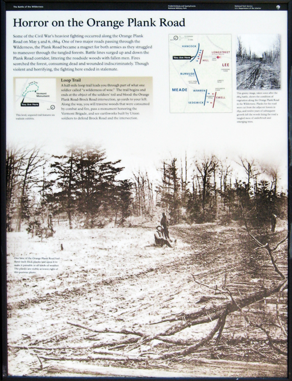
Horror on the Orange Plank Road
Some of the Civil War’s heaviest fighting occurred along the Orange Plank Road on May 5 and 6, 1864. One of two major roads passing through the Wilderness, the Plank Road became a magnet for both armies as they struggled to maneuver through the tangled forests. Battle lines surged up and down the Plank Road corridor, littering the roadside woods with fallen men. Fires scorched the forest, consuming the dead and wounded indiscriminately. Though violent and horrifying, the fighting here ended in stalemate.
Loop Trail
A half-mile loop trail leads you through part of what one soldier called “a wilderness of woe.” The trail begins and ends at the object of the soldier’ toil and blood: the Orange Plank Road-Brock Road intersection, 50 yards to your left. Along the way, you will traverse the woods that were consumed by combat and fire, pass a monument honoring the Vermont Brigade, and see earthworks built by Union soldiers to defend Brock Road and the intersection.
One lane of the Orange Plank Road had three-inch thick planks laid upon it to make it passable in all kinds of weather. The planks are visible at lower right of the postwar photo.
From the caption to the inset photo:
This grainy image, taken soon after the 1864 battle, shows the condition of vegetation along the Orange Plank Road in the Wilderness. Planks for the road were cut from the adjacent forests in 1852, and twelve years of subsequent growth left the woods lining the road a tangled mess of underbrush and emerging trees.
Location of the marker
The marker is on the southeast side of the parking area along Orange Plank Road, about 250 feet southwest of the intersection with Brock Road. (38°18’02.6″N 77°42’34.5″W)