The “Burning the Wrightsville Bridge” and “The River: A Corridor and a Barrier” wayside markers are in Wrightsville, Pennsylvania, on Walnut Street where it ends at the noat ramp on the Susquehanna River. The two markers are a short distance apart.
On June 28, 1863 the advanced guard of the Confederate Army of Northern Virginia, the troops of Brigadier General John Brown Gordon, arrived in front of Union defensive lines on the west bank of the Susquehanna River at Wrightsville, Pennsylvania. A short fight pushed the Union militia back, but Gordon’s mission to clear a bridgehead across the river to open the way to Harrisburg and Philadelphia was stymied when the Union troops burned the bridge. The next day Gordon received orders to fall back on the main army which was concentrating near Gettysburg. Along with the fighting at Carlisle on July 2, Wrightsville was the deepest penetration of the North by a large force of Confederate troops in the Eastern Theater of the Civil War.
Burning the Wrightsville bridge wayside marker
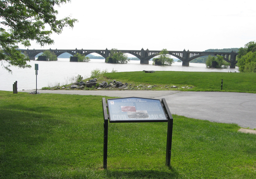
The latest version of the bridge stands just downriver with the stone piers of earlier bridges.
Burning the Wrightsville Bridge
By late June 1863, the Confederate Army had invaded Pennsylvania. After capturing York, the Reberls planned to take the state capital, Harrisburg, and possibly Philadelphia. To get there, they would need to cross the Susquehanna River at Wrightsville. Pennsylvania militiamen from Columbia, on the Lancaster side of the river, vowed to block the Confederate advance. Union troops retreating from York joined them, as did a company of African American militiamen. They mustered fewer than 1,500 men.
When Confederate Brigadier General John Brown Gordon arrived on June 28 with approximately 1,800 troops, the Federals were waiting in their entrenchments. The Rebels opened up with artillery fire, and the Union position rapidly became untenable. The Federals decided to retreat to Columbia and blow up a section of the over mile-long bridge behind them, denying the Rebels access to Lancaster. The explosions failed to destroy the bridge, so the order to burn it was given. As the Confederates surged forward, the bridge erupted in flames. Gordon’s men worked for hours to extinguish the blaze. They kept Wrightsville from going up in smoke, but the bridge was destroyed. Gordon’s Brigade was recalled to York the next day. The Pennsylvania militia had saved Lancaster.
From the captions to the two illustrations:
Illustration of the burning of the Wrightsville Bridge
Chaos in Wrightsville as the bridge burns in the background
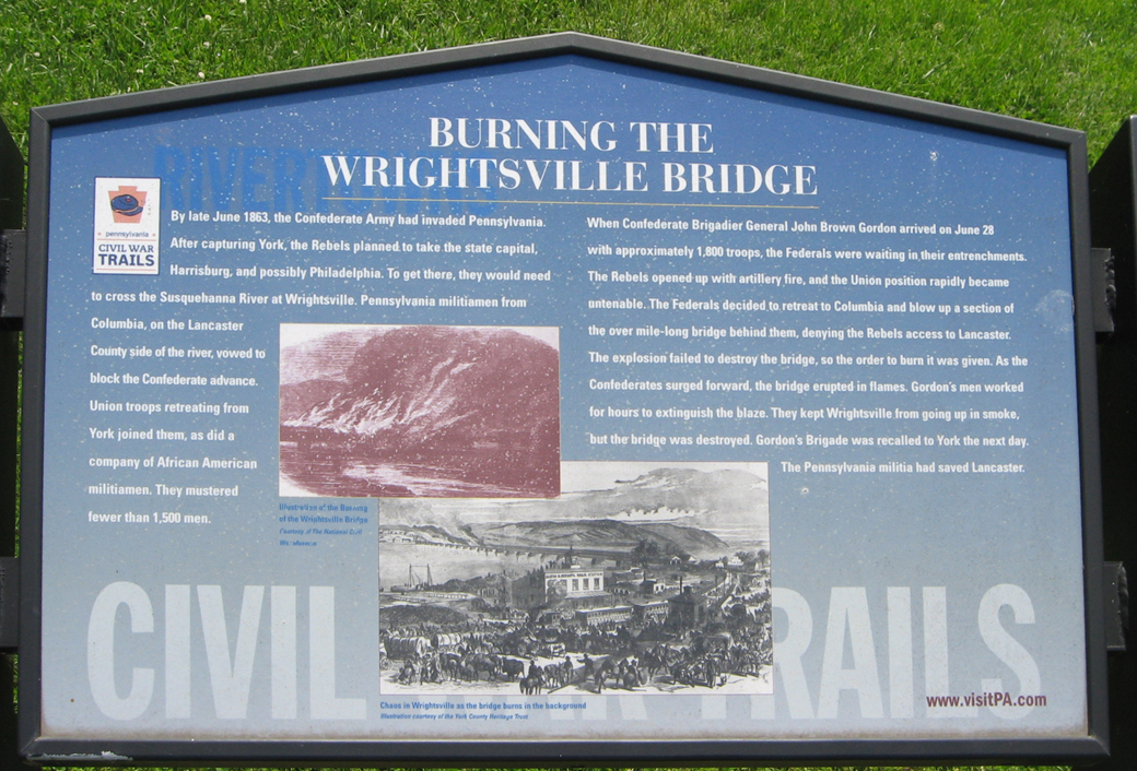

Illustration of the burning of the Wrightsville Bridge
The River: A Corridor and a Barrier wayside marker

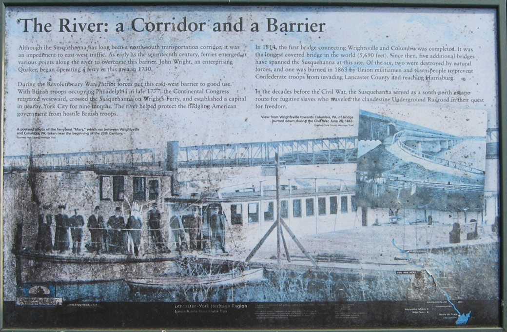
The River: A Corridor and a Barrier
Although the Susquehanna has long been a north-south transportation corridor, it was an impediment to east-west traffic. As early as the seventeenth century, ferries emerged at various points along the river to overcome this barrier. John Wright, an enterprising Quaker, began operating a ferry in this area in 1730.
During the Revolutionary War, Patriot forces put this east-west barrier to good use. With British troops occupying Philadelphia in late 1777, the Continental Congress retreated westward, crossed the Susquehanna on Wright’s Ferry, and established a capital in nearby York City for nine months. The river helped protect the fledgling American government from hostile British troops.
In 1814, the first bridge connecting Wrightsville and Columbia was completed. It was the longest covered bridge in the world (5,690 feet). Since then, five additional bridges have spanned the Susquehanna at this site. Of the six, two were destroyed by natural forces, and one was burned in 1863 by Union militiamen and townspeople to prevent Confederate forces from invading Lancaster County and reaching Harrisburg.
In the decades before the Civil War, the Susquehanna served as a south-north escape route for fugitive slaves who traveled the clandestine Underground Railroad in their quest for freedom.
From the caption to the background photo:
A postcard photo of the ferryboat “Mary” which ran between Wrightsville and Columbia, PA, taken near the beginning of the 20th Century.
From the caption to the inset photo on the right:
View from Wrightsville towards Columbia, PA, of bridge burned down during the Civil War, June 28, 1863.