
Five Forks • Tour the Battlefield • The Armies • Battle Maps
– – –
Visitor Center • Stop 1 • Stop 2 • Stop 3 • Stop 4 • Stop 5
The Five Forks National Park Service Visitor Contact Center is on the west side of Courthouse Road about 0.4 mile south of the Five Forks intersection. It is not one of the stops on the Auto Tour, but its central location makes it a good place to begin a visit to the Five Forks battlefield. (see map below) The Contact Center is open seasonally March – November.

The Center has rest rooms, drinking water and a small picnic area. An orientation marker and a wayside marker are in front of the building to help tell the story of the battle:
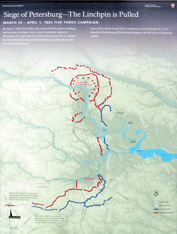
“Siege of Petersburg – The Linchpin is Pulled” orientation marker
Text from the marker:
Siege of Petersburg – The Linchpin is Pulled
March 29 – April 1, 1865 Five Forks Campaign
By April 1, 1865, Five Forks, just north of where you’re standing, had become a linchpin – key to the Confederate capital at Richmond. To control the Five Forks intersection was to control the South Side Railroad and Richmond’s last connection to the rest of the Confederacy.
Loss of Five Forks would force Confederate General Robert E. Lee to abandon Peterburg and Richmond leading to the fall of the Confederate capital.
Captions on the map:
March 29-31, 1865 – In a series of battles Grant severs the Boydton Plank Road and isolates Confederate General George Pickett’s forces at Five Forks.
April 1, 1865 – Union forces sweep the Confederates off the intersection and by nightfall Grant plans his final assault on Lee’s position the next day.
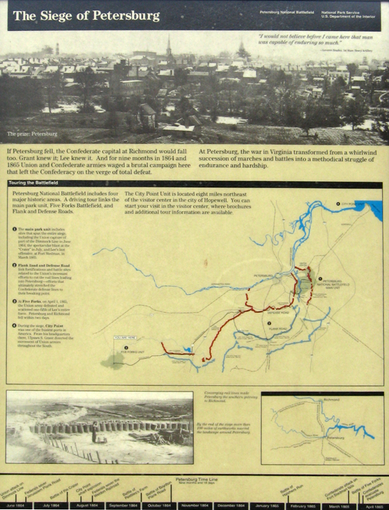
“The Siege of Petersburg” Wayside Marker
Text from the marker:
The Siege of Petersburg
“I would not believe before I came here that man was capable of enduring so much.”
– Leverett Bradley, 1st Mass. Heavy Artillery
If Petersburg fell, the Confederate capital at Richmond would fall too. Grant knew it; Lee knew it. And for nine months in 1864 and 1865 Union and Confederate armies waged a brutal campaign here that left the Confederacy on the verge of total defeat.
At Petersburg, the war in Virginia transformed from a whirlwind succession of marches and battles into a methodical struggle of endurance and hardship.
Touring the Battlefield
Petersburg National Battlefield includes four major historic areas. A driving tour links the Eastern Front and Western Front units with the Five Forks Battlefield.
The City Point Unit is located about eight miles northeast of the Visitor Center in the city of Hopewell. You can start your visit in the visitor center, where brochures and additional tour information are available.
1) The main park unit includes sites that span the entire siege, including the Union capture of part of the Dimmock Line in June 1864, the spectacular blast at the ‘Crater” in July, and Lee’s last offensive, at Fort Stedman, in March 1865.
2) Flank Road and Defense Road link fortifications and battle sites related to the Union’s incessant efforts to cut the rail lines leading into Petersburg – efforts that ultimately stretched the Confederate defense lines to their breaking point.
3) At Five Forks on April 1, 1865, the Union army defeated and scattered one-fifth of Lee’s entire force. Petersburg and Richmond fell within two days.
4) During the siege, City Point was one of the busiest ports in America. From his headquarters there, Grant directed the movement of Union armies throughout the South.
Captions to photos at the bottom:
Converging rail lines made Petersburg the southern gateway to Richmond.
By the end of the siege more than 100 miles of earthworks marred the landscape around Petersburg.
Map and directions to the Visitor Contact Center
The Five Forks National Park Service Visitor Contact Center is on the east side of Courthouse Road (Route 627) about 0.4 mile south of the Five Forks Intersection. (37°08’06.7″N 77°37’10.3″W)
Directions to the next stop on the Auto Tour:
Turn right out of the Visitor Contact Center onto Courthouse Road for 0.1 mile. The parking area for Stop One is on the left.