
Cold Harbor • Tour the Battlefield • Monuments & Markers • The Armies
The Cold Harbor Battlefield Walking Trail orientation display is at the south edge of the parking area at Hanover County Park. (see map below)
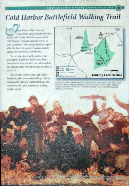
Text from the marker:
Cold Harbor Battlefield Walking Trail
For thirteen days Union and Confederate armies faced each other around Cold Harbor, their lines separated by only 150 yards of ravaged ground. Twice, on June 1 and June 3 1864, savage fighting erupted when the Federals launched massive assaults against the entrenched Confederates.
You are standing near the center of the Union lines, held by the Sixth Corps. From here, Grant’s lines extended two miles south to the Chickahominy River and nearly five miles to the north.
To view this section of the Cold Harbor battlefield, take the one-mile walking trail that winds past the historic Garthright House and well-preserved Union infantry and artillery emplacements.
Text from the caption below the map:
Across the road is the Cold Harbor National Cemetery, the final resting-place for many of the Federal soldiers who died in the fighting. A half-mile to the west is a section of the Cold Harbor battlefield managed by the National Park Service. Park facilities, including a visitor center, driving tour, and walking trail, are open daily.
From the caption to the background painting:
The Skirmish Line by artist Gilbert Gaul depicts the intensity of combat for Union soldiers at Cold Harbor. Courtesy of West Point Museum Collection, United States Military Academy.
Location of the marker
The marker is at the Hanover County Park on the south side of Cold Harbor Road about 650 feet east of the National Cemetery and next to Gathright House. It is next to the beginning of the park’s walking trail.