
Battle of Fisher’s Hill • Tour the Battlefield • 1864 Shenandoah Timeline
The ‘Valley Pike – Tumbling Run Near Fisher’s Hill’ wayside marker is on the north side of the Valley Pike (U.S. 11) about 1.1 miles south of Strasburg and 300 feet north of Battlefield Road (County Route 601). 
From the marker:
Valley Pike
Tumbling Run Near Fisher’s Hill
1864 Valley Campaign
Here on Tumbling Run are the remains of the “Old Pike” stone bridge. The Valley Turnpike Company was chartered in 1838 as a joint-stock corporation. The turnpike followed the route of the Great Wagon Road from Philadelphia to the backcountry of the Carolinas, a major migration route of the mid-18th century. First an Indian path, then a wagon road, by the time of the Civil War the turnpike was a hard-surfaced macadamized commercial highway. Lack of maintenance and overuse by the armies during all the seasons meant that soldiers often had to repair roads or clear new ones while campaigning. During the Civil War, nine major battles were fought in the Shenandoah Valley along the Valley Turnpike. Many more battles and engagements took place on other Valley thoroughfares since the armies marched on the most accessible and advantageous routes, which were also the historic routes used for commerce and private travel. Road networks and intersections often dictated where battles occurred. Roads were also essential to the vast logistical trains that followed the armies, including baggage wagons, herds of stock, fresh horses, ambulances, artillery pieces, and caissons.
During the battles of Fisher’s Hill, September 22, 1864 and Cedar Creek, October 19, 1864, the bridge here was important for the marching armies because it supplemented the natural defensive terrain of Fisher’s Hill as a line of communication. During the Battle of Cedar Creek, the bridge became a “choke point” as fleeing wagons, artillery caissons, and demoralized Confederate soldiers forced their way across the stream.

Map of the Battle of Fisher’s Hill, September 22, 1864
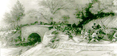
Graphic and caption from the marker: “Scene of Confederate Rout over Tumbling Run after Battle of Cedar Creek on October 19, 1864.” by James E. Taylor, Courtesy of Western Reserve Historical Society.
The Valley Pike – Tumbling Run Near Fisher’s Hill wayside marker
The marker is on the north side of the Valley Pike (U.S. 11) about 1.1 miles south of Strasburg and 300 feet north of Battlefield Road (County Route 601). (38°58’51.1″N 78°23’17.0″W)