
Battle of Fredericksburg • Tour the Battlefield • Monuments & Markers • Armies
There are three wayside markers at the Fredericksburg City Dock. They are not part of the Fredericksburg Battlefield Auto Tour but are just a three block side trip from the route. (see map below)

The three wayside markers are together on the west side of the City Dock parking area.
Bridges and Biscuits wayside marker
Text from the marker:
Fredericksburg City Dock
Bridges and Biscuits
Why was Fredericksburg important to the Union war effort? The answer lies in logistics. The Union army, numbering more than 100,000 troops, required tons of food, clothing and other supplies to operate, Wagon trains could supply the army for short distances, but they were cumbersome and difficult to protect. Longer supply lines required either water or rail transportation. Fredericksburg, with its railroad and close proximity to the Potomac River, provided the Union Army with an ideal base for an “On to Richmond” drive.
Three bridges spanned the Rappahannock River here in 1861: the Richmond, Fredericksburg, and Potomac Railroad bridge (which stood at the same location as the modern bridge ahead of you) and two wagon bridges located farther upstream. Retreating Confederates destroyed these spans in April 1862, making it necessary for the Union army to cross the river on pontoon bridges the following December during the Battle of Fredericksburg. The middle pontoon bridge stood here at the city dock.
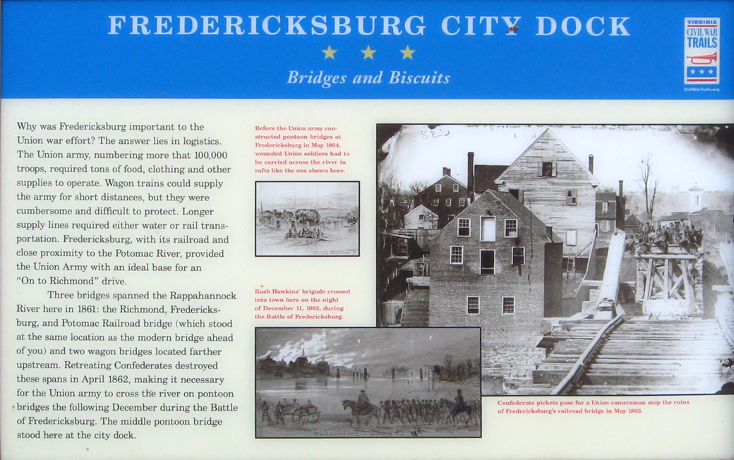
From the photo caption on the top:
Before the Union Army constructed pontoon bridges at Fredericksburg in May 1864, wounded Union soldiers had to be carried across the river in rafts like the one shown here.
From the photo caption in the center:
Rush Hawkins’ brigade crossed into town here on the night of December 11, 1862 during the Battle of Fredericksburg.
From the photo caption on the lower right:
Confederate pickets pose for a Union cameraman atop the ruins of Fredericksburg’s railroad bridge in May 1863
Contesting the Crossing wayside marker

Text from the marker:
Fredericksburg City Dock
Contesting the Crossing
Confederate troops under the command of Gen. William Barksdale were awake and alert hereon the morning of December 11,1862, waiting anxiously for the sun to rise. On the river, unseen in the inky blackness but clearly audible in the night’s stillness, Union engineers were constructing a pontoon bridge that would enable Gen. Ambrose E. Burnside’s Army of the Potomac to cross the Rappahannock River and seize Fredericksburg. Barksdale’s task was to delay the Union crossing long enough for the rest of the Confederate army to take position on the heights behind the town, one mile ahead of you.
As the sun rose, Barksdale’s men could vaguely discern the shadowy figures of the Union engineers, now just a few dozen yards from the Confederate shore. Shots broke down the silence – first one or two, then hundreds. Engineers fell dead on the bridge or dashed to the safety of the opposite shore. Union cannon replied to the Confederate fire with a savage but largely ineffective bombardment of the town. Time and again, engineers dashed out to complete the bridge only to be driven back by sharpshooters concealed behind walls and in houses like the one in front of you.
For ten hours the fighting continued. About 4 p.m., soldiers from New York, Michigan, and Massachusetts rowed across the river under fire and pushed the Confederates back from the water’s edge, The engineers completed the bridges, and the next day more than 30,000 Union soldiers poured across. But Barksdale’s stubborn stand had bought Gen. Robert E. Lee the time he needed to assemble his army on the hills behind the town. The stage was set for a slaughter at Fredericksburg.
From the caption to the drawing on the upper left:
Confederate sharpshooters, shelter inside buildings, behind fences and in rifle pits, delayed the Union crossing for several hours.
From the caption to the drawing on the lower right:
Union troops cross the Rappahannock River under fire.
Union Artillery on Stafford Heights wayside marker
Text from the marker:
Fredericksburg City Dock
Union Artillery on Stafford Heights
Directly ahead of you, across the river, stood George Washington’s boyhood home, Ferry Farm. According to legend, the future president cut down his father’s cherry tree there and threw a coin across the river. The property took its name from a ferry that operated at that time.
In 1862, Union artillery crowned the bluffs once occupied by the Washington farm. When Confederate troops resisted the Union army’s efforts to cross the river on December 11, Burnside turned nearly 150 guns – arrayed along a three-mile front – on the town. Thousands of shells, some weighing as much as thirty pounds, crashed down upon the unfortunate city, setting several buildings on fire. But when the smoke cleared, the Confederates were still there.
“…The Yankees were throwing all their missils [sic] into the City of Fredericksburg, seemingly with the intention of demolishing every vestige of the human race, not leaving even the sign of City or even a house ….” – William White, 18th Georgia Infantry
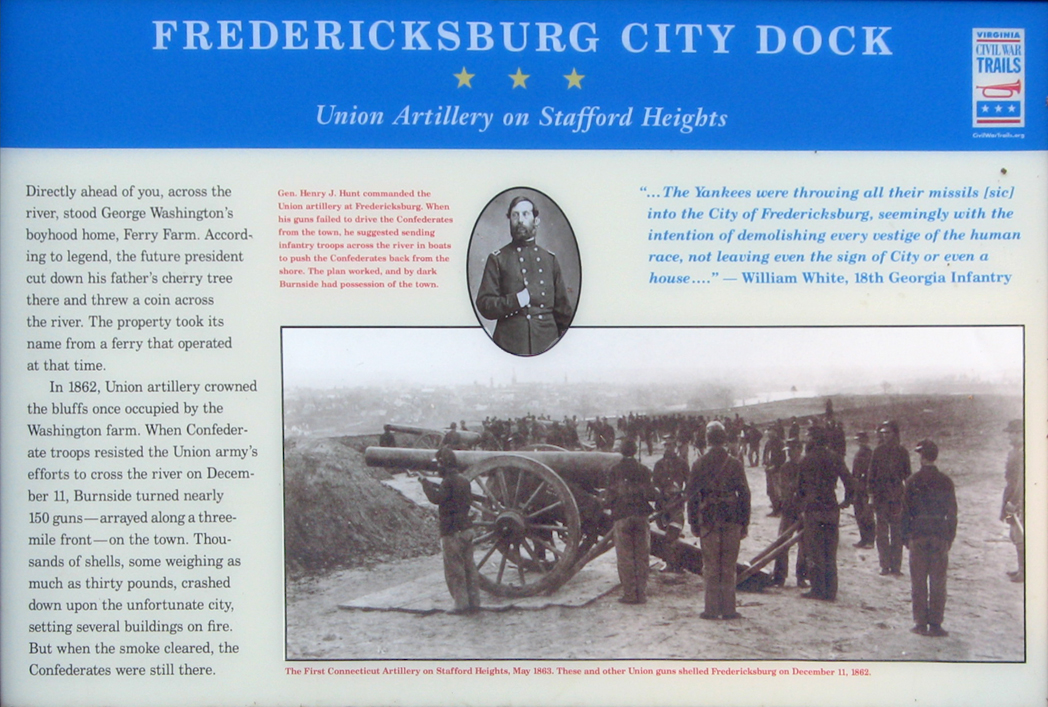
From the caption to the small inset photo at the top:
Gen. Henry J. Hunt commanded the Union artillery at Fredericksburg. When his guns failed to drive the Confederates from the town, he suggested sending infantry troops across the river in boats to push the Confederates back from the shore. The plan worked, and by dark Burnside had possession of the town.
From the caption to the large inset photo at the bottom:
The First Connecticut Artillery on Stafford Heights, May 1863. These and other Union guns shelled Fredericksburg on December 11, 1862.
Directions to the Fredericksburg City Dock
The wayside markers and monument at the City Dock are at the end of Sophia Street along the Rappahannock River waterfront in Fredericksburg, Virginia. (38°17’47.5″N 77°27’13.2″W)