
Battle of Fredericksburg • Tour the Battlefield • Monuments & Markers • Armies
 At the top of Lee’s Hill was the Confederate command post for the battle. Here there is a monument, a map display, two wayside markers and an Exhibit Shelter. (see map below)

The large aluminum map display is on the left in the photo with the two wayside markers on each side of the concrete riser, with the monument behind the Exhibit Shelter on the right.
Lee’s Hill Monument
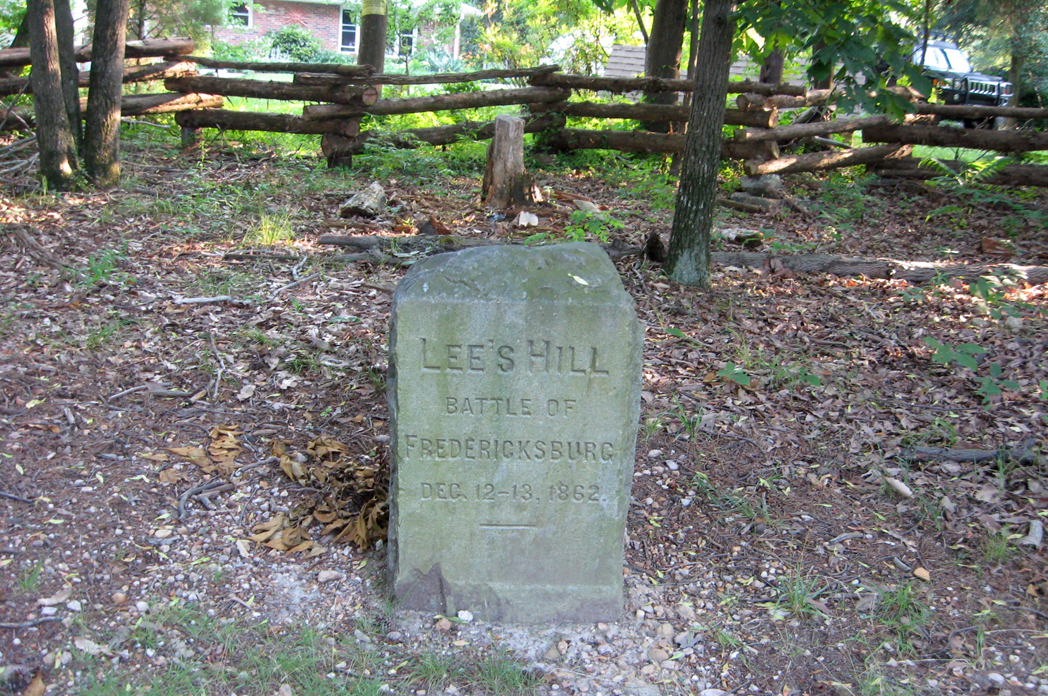
The monument is one of a series placed around Fredericksburg and Spotsylvania County in 1903 by the Reverend James Powers Smith, who had been a lieutenant on the staff of Confederate Lieutenant General Thomas J. Jackson. The monuments were largely paid for by businessman Thomas F. Ryan.
Other Smith monuments are the Lee-Jackson Bivouac at Chancellorsville, Arm of Stonewall Jackson at Ellwood, Stuart and Pelham at Fredericksburg, Jackson on the Field at Fredericksburg, Battle of Salem Church, Stonewall Jackson died at Guinea Station, Lee to the Rear at the Wilderness, and Lee’s Headquarters at Spotsylvania.
Text from the monument:
Lee’s Hill
Battle of
Fredericksburg
Dec. 12-13, 1862
The Battle of Fredericksburg from Lee’s Hill map display
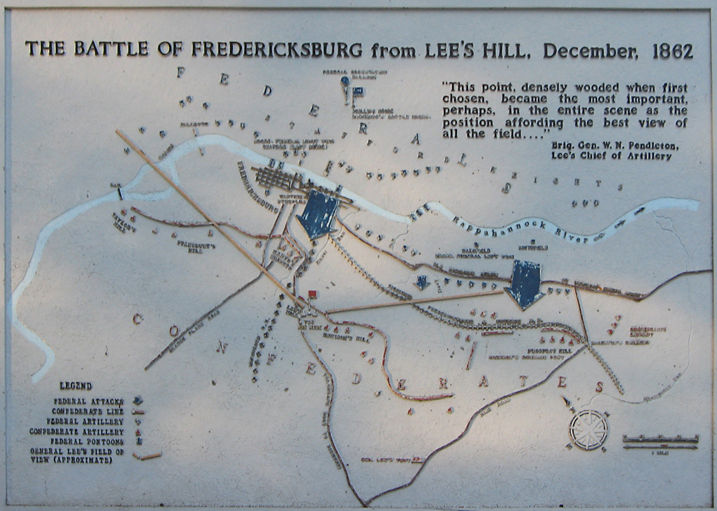
Text from the marker:
The Battle of Fredericksburg from Lee’s Hill
“This point, densely wooded when first chosen, became the most important, perhaps, in the entire scene as the position affording the best view of all the field…”
Brig. Gen. W.N. Pendleton
Lee’s Chief of Artillery
Legend
Federal attacks
Confederate Line
Confederate Artillery
Federal Pontoons
General Lee’s Field of View (Approximate)
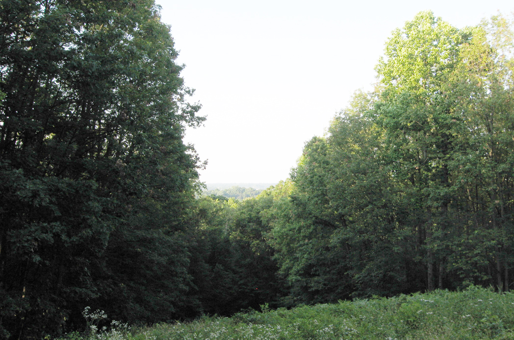
The view from the hill (from the concrete riser in front of the marker) is much reduced from what Robert Lee saw in 1862 by the heavy woods. A small “window” has been kept open, but it is now growing closed.
Lee’s Command Post wayside marker
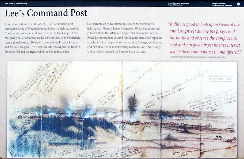
Text from the marker:
Lee’s Command Post
This hill served as General Robert E. Lee’s command post during the Battle of Fredericksburg. Before the fighting started, Confederate pioneers cut down trees on the front slope of the hill, giving the Confederate leader a better view of the battlefield than is possible today. To his left, he could see Fredericksburg and Marye’s Heights. To his right was the broad plain in front of Prospect Hill and the right end of the Confederate line.
Lee spent much of December 13, 1862, here, watching the fighting with General James Longstreet. When Lee expressed concern about the safety of Longstreet’s men in the Sunken Road, his subordinate assured him that his men could repel the attackers, “Give me plenty of ammunition,” Longstreet boasted, and “I will kill them all before they reach my line.” Not a single Union soldier reached the Sunken Road that day.
It did me good to look upon General Lee and Longstreet during the progress of the battle and observe the complacent, cool and satisfied air yet intense interest which their countenances… manifested.”
Sergeant William B. Pettit, Fluvanna Artillery, Confederate staff officer
From the caption to the background drawing:
Artist Frank Vizetelly sketched this scene from Lee’s Hill for the Illustrated London News
Near Disaster wayside marker

Text from the marker:
Near Disaster
On this hill on December 13, 1862, Confederate General Robert E. Lee twice nearly met personal disaster. While firing its 39th round of the day, a 30-pounder Parrott Rifle (like the one in front of you) burst, sending chunks of metal across the hilltop – narrowly missing Generals Lee and Longstreet.
Later, a Union artillery shell fired from Stafford Heights, more than a mile away, buried itself in the earthworks at Lee’s side. The shell failed to explode. Meanwhile, Confederate cannons here continued their deadly work, adding to the horror of Union troops trapped in front of Marye’s Heights and the Sunken Road.
From the caption to the background drawing:
A Confederate gun fires from what would become known as Lee’s Hill.
Location of the top of Lee’s Hill
The top of Lee’s Hill can be reached by a steep trail that switchbacks up the hillside from the parking area. (38°17’06.0″N 77°28’34.6″W) The Park Service recommends. “Although only about .25 mile long, the trail is steep. Allow 45 minutes for the roundtrip hike.”