
Harpers Ferry Main • Tour the Battlefield > Murphy Farm • Timeline
Three wayside markers at the end of the Murphy’s Farm Trail (see map below) tell the story of John Brown’s Fort during its temporary stay here from 1895 to 1909.
A Moving Symbol wayside marker

Text from the marker:
A Moving Symbol
In it really began the Civil War.
Here was lighted the torch of liberty for all America…
For you this is the most hallowed shrine in this country.
Henry McDonald,
Storer College president
The foundations in front of you mark a temporary site of John Brown’s Fort, from 1895 to 1909. Originally located in Harpers Ferry, the fort was moved four times in 75 years. Entrepreneurs dismantled it and then rebuilt it on location at the 1893 Columbian Exposition in Chicago. After the exhibition, journalist Kate Field saved the fort from demolition by raising the funds to move it here to Murphy Farm. In 1901 Storer College President Henry McDonald brought the fort to the college’s Harpers Ferry campus. After the closing of Storer College the National Park Service returned the fort near its original location in Harpers Ferry (lower town), where it stands today.
Photo captions from upper right:
Original location of fort in Harpers Ferry (lower town 1865).
Moved to Storer College Campus, Harpers Ferry (Camp Hill) in 1909.
Returned to Harpers Ferry (lower town) in 1968.
Alexander Murphy, for the sum of one dollar, donated five acres of his farm to Kate Field (left) to reconstruct and preserve the John Brown Fort in 1895. It stood here at the farm (main photo) until 1910. Murphy permitted the public to visit the fort without charge.

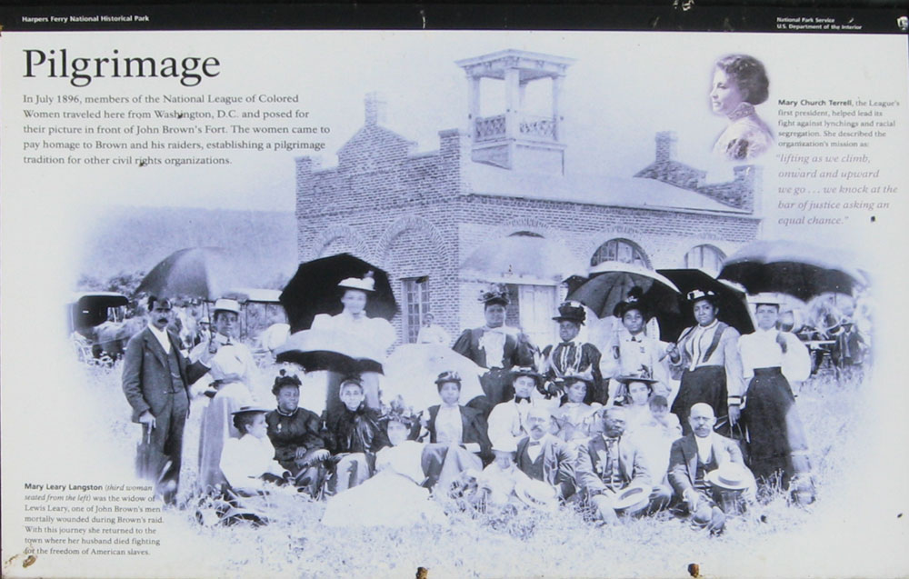
Pilgrimage wayside marker
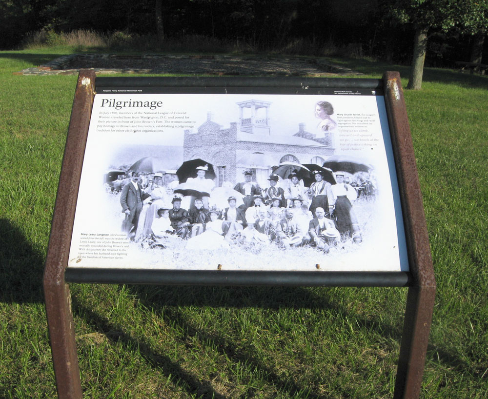
Text from the marker:
Pilgrimage
In July 1896, members of the National League of Colored Women traveled here from Washington, D.C. and posed for their picture in front of John Brown’s Fort. The women came to pay homage to Brown and his raiders, establishing a pilgrimage tradition for other civil rights organizations.
Mary Church Terrell, the League’s first president, helped lead its fight against lynchings and racial segregation. She described the organization’s mission as: “lifting as we climb, onward and upward we go…we knock at the bar of justice asking an equal chance.”
Mary Leary Langston (third woman seated from the left) was the widow of Lewis Leary, one of John Brown’s men mortally wounded during Brown’s raid. With this journey she returned to the town where her husband died fighting for the freedom of American slaves. In the upper left is a portrait of Mary Church Terrell.
Holy Ground wayside marker
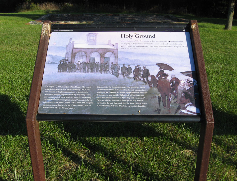
Text from the marker:
Holy Ground
Here on the scene of John Brown’s martyrdom we reconsecrate ourselves, our honor, our property to the final emancipation of the race which John Brown died to make free… Thank God for John Brown!… and all the hallowed dead who died for freedom!
W.E.B. Du Bois,
Niagara Movement general secretary and
NAACP founding member
On August 17, 1906, members of the Niagara Movement walked silently past where you are standing. One of the first modern civil rights organizations in America, the Niagara Movement fought for racial equality and political representation at all social levels. Its members’ efforts laid the foundation for creating the National Association for the Advancement of Colored People (NAACP) in 1909. Niagara participants came here to the site of John Brown’s Fort to honor Brown, who died to end slavery.
Black scholar Dr. Benjamin Quarles described their arrival: “As they neared their destination they formed a procession, single file, led by Owen M. Waller, a physician from Brooklyn. Defying stone and stubble, Waller took off his shoes and socks and walked barefoot as if treading on holy ground.” Other members followed suit and together they walked barefoot to the fort. As they circled the fort they sang verses of John Brown’s Body and The Battle Hymn of the Republic.
Map to the temporary John Brown Fort site on Murphy’s Farm
Three wayside markers are at the fort site: Holy Ground, Pilgrimage and A Moving Symbol. They are at the end of the Murphy’s Farm Trail about 750 yards south of the trailhead parking area on Murphy Road. From Shenandoah Street (the road to the Visitor Center) take Campground Road 0.25 mile west, then turn left on Murphy Road for 0.3 mile. (39°18’28.1″N 77°45’42.6″W)
(go to the main Murphy Farm page)
(go to the main Tour the Harpers Ferry Battlefield page)