
Battle of Brandy Station • Tour the Battlefield • Historical & Wayside Markers • The Armies
“The Stone Wall on the Cunningham Farm” wayside marker on is the fourth and final stop on the Buford’s Knoll walking trail. (38°32’38.3″N 77°51’32.0″W; map). It s a little less than a mile from the trailhead on Beverly Ford Road north of the James Madison Highway (U.S. 15 & 29), north of the Culpeper Regional Airport. It is next to the “Rooney Lee’s Fighting Retreat” wayside marker.

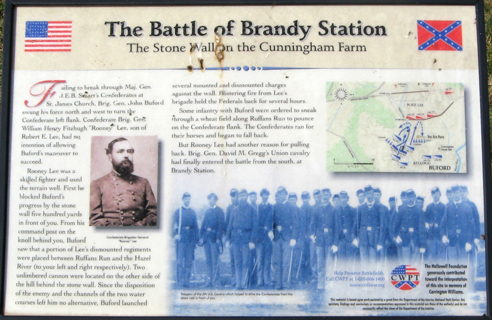
Text from the marker:
The Battle of Brandy Station
The Stone Wall on the Cunningham Farm
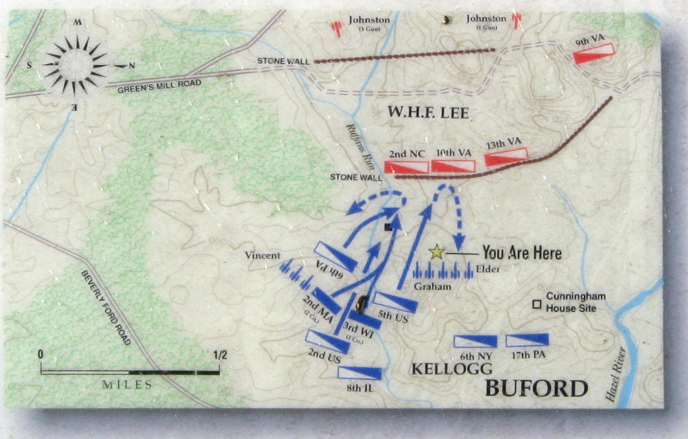
Failing to break through Maj. Gen. J.E.B. Stuart’s Confederates at St. James Church, Brig. Gen. John Buford swung his force north and west to turn the Confederate left flank. Confederate Brig. Gen. William Henry Fitzhugh “Rooney” Lee, son of Robert E. Lee, had no intention of allowing Buford’s maneuver to succeed.
Rooney Lee was a skilled fighter and used the terrain well. First he blocked Buford’s progress by the stone wall five hundred yards in front of you. From his command post on the knoll behind you, Buford saw that a portion of Lee’s dismounted regiments were placed between Ruffans Run and the Hazel River (to your left and right respectively). Two unlimbered cannon were located on the other side of the hill behind the stone wall. Since the disposition of the enemy and the channels of the two water courses left him no alternative, Buford launched several mounted and dismounted charges against the wall. Blistering fire from Lee’s brigade held the Federals back for several hours.
Some infantry with Buford were ordered to sneak through a wheat field along Ruffans Run to pounce on the Confederate flank. The Confederates ran for their horses and began to fall back.
But Rooney Lee had another reason for pulling back. Brig. Gen. David M. Gregg’s Union cavalry had finally entered the battle from the south, at Brandy Station.
Help Preserve Battlefields
Call CWPT at 1-888-606-1400
www.civilwar.org
The Hallowell Foundation generously contributed toward the interpretation of this site in memory of Carrington Williams.
This material is based upon work assisted by a grant from the Department of the Interior, National Park Service. Any opinion, findings and conclusions or recommendations expressed in this material are those of the author(s) and do not necessarily reflect the views of the Department of the Interior.
Photo captions:
Confederate Brigadier General “Rooney” Lee
Troopers of the 5th U.S. Cavalry which helped to drive the Confederates from the stone wall in front of you.
Location of the markers on Bufotd’s Knoll
Buford’s Knoll and wayside markers “The Stone Wall on the Cunningham Farm” and “Rooney Lee’s Fighting Retreat” are on the Buford’s Knoll Walking Trail about one mile north of the trailhead and parking area. (38.53247° N, 77.85802° W)