
Battle of Brandy Station • Tour the Battlefield • Historical & Wayside Markers • The Armies
The “Confederate Line of Defense at St. James Church” wayside marker is the fourth and final stop on the St. James Church walking trail. The St. James Church trailhead is at the intersection of St. James Church Road and Beverly Ford Road. 
The view is looking northeast in the direction of the attacking Union cavalry.
Text from the marker:
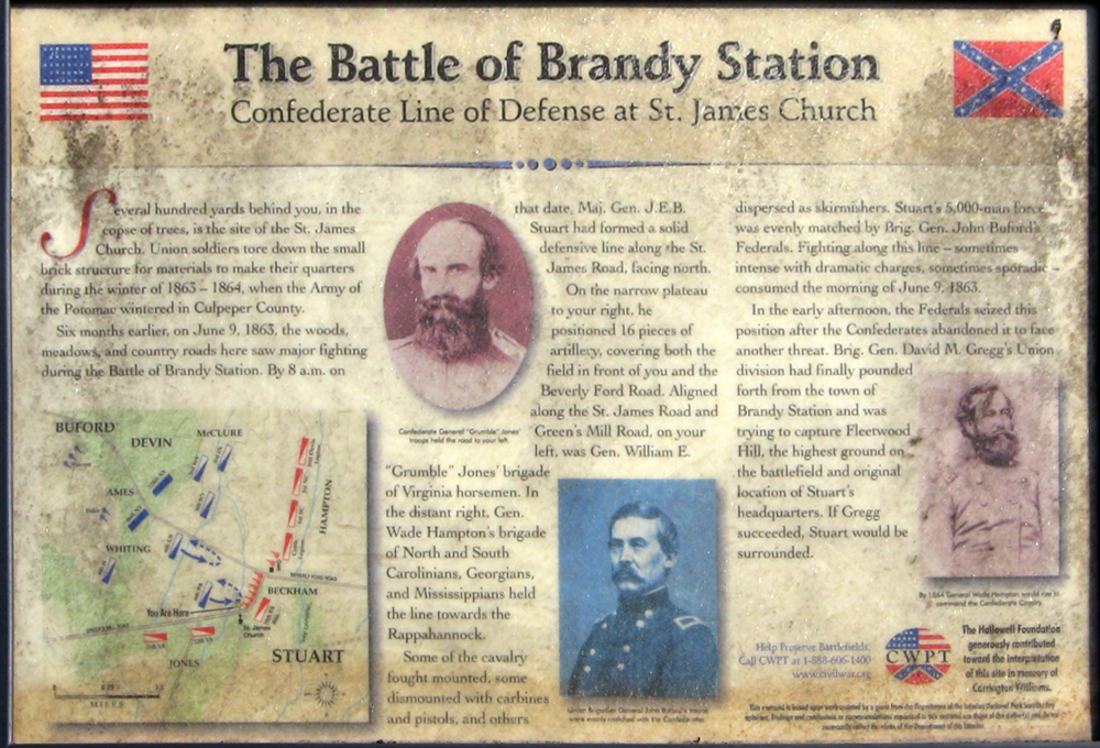
The Battle of Brandy Station
Confederate Line of Defense at St. James Church
Several hundred yards behind you, in the copse of trees, is the site of the St. James Church. Union soldiers tore down the small brick structure for materials to make their quarters during the winter of 1863-1864, when the Army of the Potomac wintered in Culpeper County.
Six months earlier, on June 9, 1863, the woods, meadows, and country roads here saw major fighting during the Battle of Brandy Station. By 8 a.m. on that date, Maj. Gen. J.E.B. Stuart had formed a solid defensive line along the St. James Road, facing north.
On the narrow plateau to your right, he positioned 16 pieces of artillery, covering both the field in front of you and the Beverly Ford Road. Aligned along the St. James Road and Green’s Mill Road, on your left, was Gen. William E. “Grumble” Jones’ brigade of Virginia horsemen. In the distant right, Gen. Wade Hampton’s brigade of North and South Carolinians, Georgians, and Mississippians held the line towards the Rappahannock.
Some of the cavalry fought mounted, some dismounted with carbines and pistols, and others dispersed as skirmishers. Stuart’s 5,000-man force was evenly matched by Brig. Gen. John Buford’s Federals. Fighting along this line – sometimes intense with dramatic charges, sometimes sporadic – consumed the morning of June 9, 1863.
In the early afternoon, the Federals seized his position after the Confederates abandoned it to face another threat. Brig. Gen. David M. Gregg’s Union division had had finally pounded forth from the town of Brandy Station and was trying to capture Fleetwood Hill, the highest ground on the battlefield and original location of Stuart’s headquarters. If Gregg succeeded, Stuart would be surrounded.
Help Preserve Battlefields
Call CWPT at 1-888-606-1400
www.civilwar.org
The Hallowell Foundation generously contributed toward the interpretation of this site in memory of Carrington Williams.
This material is based upon work assisted by a grant from the Department of the Interior, National Park Service. Any opinion, findings and conclusions or recommendations expressed in this material are those of the author(s) and do not necessarily reflect the views of the Department of the Interior.
Photo captions (from left to right):
Confederate General “Grumble” Jones’ troops held the road to your left
Union Brigadier General John Buford’s troops were evenly matched with the Confederate riders
By 1864 General Wade Hampton would rise to command the Confederate Cavalry
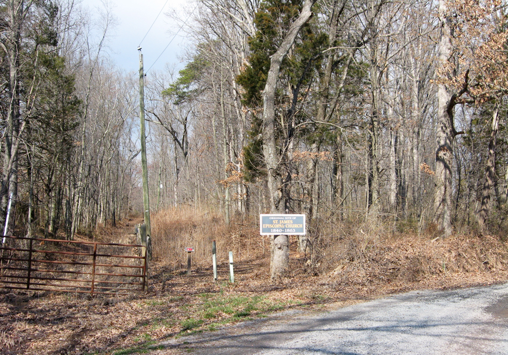
Site of St. James Church, across St. James Church Road from the Brandy Station battlefield land preserved by the Civil War Trust. The church was demolished for building materials when the area was the encampment of the Army of the Potomac over the winter of 1863-64.
Location of the marker
The marker is the fourth stop on the Civil War Trust St. James Church Walking Trail of the the Battle of Brandy Station. (38°31’24.1″N 77°52’03.0″W)