
Battle of Salem Church • Tour the Battlefield
The ‘Churchyard to Battleground’ Orientation Marker is one of a set of three markers next to the parking lot south of historic Salem Church along Plank Road (Virginia Route 3) 4 miles west of downtown Fredericksburg, Virginia and 1.5 miles west of exit 130 on Interstate 95 (38° 17.346′ N, 77° 31.873′ W; map to historic Salem Church)
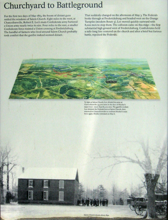
Churchyard to Battleground
For the first two days of May 1863, the boom of distant guns rattled the windows of Salem Church. Eight miles to the west, at Chancellorsville, Robert E. Lee’s main Confederate army battered a Union army nearly twice its size. Four miles to the east, a smaller Confederate force resisted a Union crossing at Fredericksburg. The handful of farmers who lived around Salem Church probably took comfort that the gunfire indeed seemed distant.
That suddenly changed on the afternoon of May 3. The Federals broke through at Fredericksburg and headed west on the Orange Turnpike (modern Route 3). Lee moved quickly eastward with 8,000 men to stop them. The collision came on this ridge – the first substantial high ground west of Fredericksburg. Confederates held a mile-long line centered on the church and after a brief but furious battle, repulsed the Federals.
From the caption to the map:
To fight at Salem Church, Lee divided his army at Chancellorsville (43,000 men) in the face of Hooker’s main force – more than 80,000 men. The gamble worked. Lee defeated the Federals here at Salem Church, then returned to Chancellorsville to confront Hooker’s main force again. Hooker retreated on May 6.
From the caption to the photo:
Salem Church shown about 1890.

Set of three orientation markers next to the parking area at Historic Salem Church. The church is in the background.