
White Oak Road • Tour the Battlefield • The Armies • Battle Maps
The Civil War Trust has preserved part of the White Oak Road battlefield and has developed a 2/3 mile walking trail. Six interpretive markers along the trail tell the story of the battle. The parking area for the trail is about 1.7 miles west of Boydton Plank Road and 4.4 miles east of Five Forks. (37°09’07.2″N 77°32’58.2″W; map)
Click on the map or the menu below to see the wayside markers.
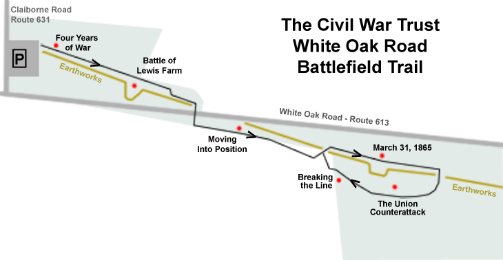
Wayside markers along the White Oak Road battlefield trail (in order):
Four Years of War
Battle of Lewis Farm
Moving Into Position
March 31, 1865
The Union Counterattack
Breaking the Line
From the marker at the parking area:
Welcome to the Civil War Preservation Trust’s White Oak Road Battlefield! The battlefield walking trail is a two-thirds-of-a-mile path that takes you past six wayside signs interpreting the 1865 battle, the remains of the Confederate earthworks, and two well preserved gun emplacements. Allow one hour to walk this trail.
The trail has a hard-packed walking surface; please do not stray from this trail. Beware of ticks and snakes that thrive in the woods surrounding the trail. Please stay off the earthworks to preserve them for future visitors.
Most importantly, please enjoy your time in these beautiful woods and reflect that this experience would have been significantly different if this land had been paved over to build a shopping mall or subdivision. To help CWPT preserve other battlefields like White Oak Road, please call 1-888-606-1400.
The Roller-Bottimore Foundation generously contributed to interpretation at CWPT’s Petersburg-area battlefields.
Help Preserve Battlefields, Call CWPT at 1-888-606-1403. www.civilwar.org

Part of this battlefield
|