
The C&O Canal Aqueduct wayside marker is on the west side of the C&O Canal Towpath next to the Cushwa Basin of the C&O Canal National Historic Park in Williamsport, Maryland. It is next to two other markers, Gettysburg Campaign – Invasion and Retreat and Williamsport – Beginning and End. (39°36’02.8″N 77°49’39.5″W; map)
From the marker
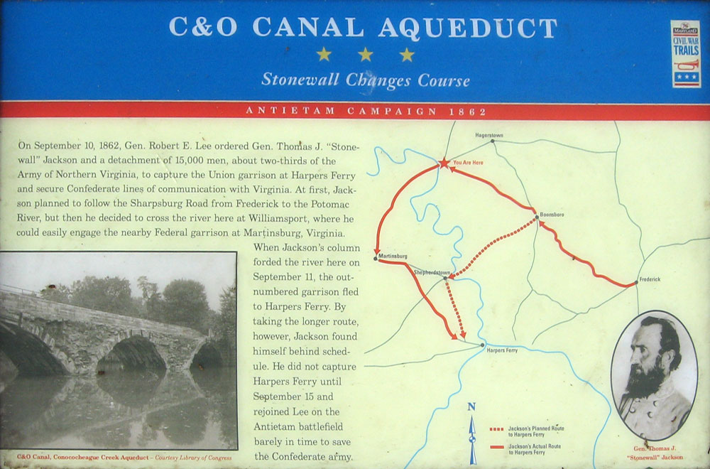
C&O Canal Aqueduct
Stonewall Changes Course
Antietam Campaign 1862
On September 10, 1862, Gen. Robert E. Lee ordered Gen. Thomas J. “Stonewall” Jackson and a detachment of 15,000 men, about two-thirds of the Army of Northern Virginia, to capture the Union garrison at Harpers Ferry and secure Confederate lines of communication with Virginia. At first, Jackson planned to follow the Sharpsburg Road from Frederick to the Potomac River, but then he decided to cross the river here at Williamsport, where he could easily engage the nearby Federal garrison at Martinsburg, Virginia.
When Jackson’s column forded the river here on September 11, the outnumbered garrison fled to Harpers Ferry, By taking the longer route, however, Jackson found himself behind schedule. He did not capture Harpers Ferry until September 15 and rejoined Lee on the Antietam battlefield barely in time to save the Confederate army.
Caption from the photo:
C&O Canal, Conococheague Creek Aqueduct.
Courtesy Library of Congress
(return to the main Tour Williamsport page)