
Battle of Spotsylvania • Tour the Battlefield • Monuments & Markers • The Armies
The “Confederate Earthworks” display and wayside marker and “Grant’s May 18th Attack” wayside marker are a side trip from the Auto Tour at the western end of Anderson Drive about 1/3 mile west of Tour Stop Three. They are next to the Grant’s May 18th Attack wayside marker.
Anderson Drive originally continued on a short distance west to connect with Brock Road, and a small section of original Confederate earthworks was leveled at the time of construction in the 1930s. After that entrance to the park was closed, the gap in the earthworks became an ideal location to recreate the original earthworks to show how they would look before 150 years of erosion had worn them down.

Civil War Earthworks wayside marker
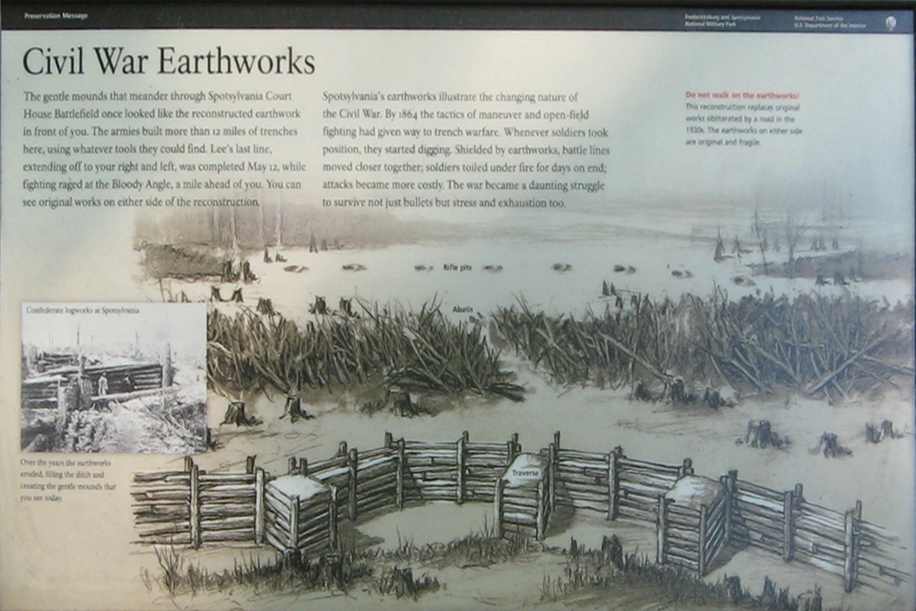
Civil War Earthworks
The gentle mounds that meander through Spotsylvania Court House battlefield once looked like the reconstructed earthwork in front of you. The armies built more than 12 miles of trenches here, using whatever tools they could find. Lee’s last line, extending off to your right and left, was completed May 12, while fighting ranged at the Bloody Angle, a mile ahead of you. You can see original works on either side of the reconstruction.
Spotsylvania’s earthworks illustrate the changing nature of the Civil War. By 1864 the tactics of maneuver and open-field fighting had given way to trench warfare. Whenever soldiers took position, they started digging. Shielded by earthworks, battle lines moved closer together; soldiers toiled under fire for days on end; attacks became more costly. The war became a daunting struggle to survive not just bullets but stress and exhaustion too.
Do not walk on the earthworks!
This reconstruction replaces original works obliterated by a road in the 1930s. The earthworks on either side are original and fragile.
Over the years the earthworks eroded, filling the ditch and creating the gentle mounds that you see today.
Civil War Earthworks display
This reconstruction of the earthworks used on the Spotsylvania battlefield replaces a short section of original works that were destroyed during road construction in the 1930s. The defenders would first build a barricade of logs held in place by upright posts. The view below shows the defender’s side of the works.

This photo shows the defender’s side of the earthworks, which protected much of the men’s bodies. You can see the small gap underneath the head log which allowed the men to shoot from behind almost total cover. The photo below shows the attacker’s side of the same barricade.
The front of the log barricade (below) was protected by a layer of dirt thick enough to stop small arms fire. Often a small gap between the earth and the top log (called a head log) was built to allow defenders to fire through the earthworks without exposing themselves over the top. These type of defences could be put up very rapidly in the wooded Virginia countryside, with soldiers using mess tins, cups and their bare hands to pile up the protective dirt.
On the far side of the sign in the photo (which reads “Confederate Trenches. Lee’s Final Line) are the remains of the original Confederate earthworks. The logs have rotted away and 150 years of rain and snow has worn down the dirt, but you can still see them. Please respect the fragility of these relics from the past and avoid walking on them so that they will be there for future visitors.

This view shows the reverse of the above photo, which is what an attacker would see. The defenders would by mostly hidden behind the log and earth barrier, with just their weapons showing through the gap beneath the head log.
Grant’s May 18th Attack wayside marker
Text from the marker:
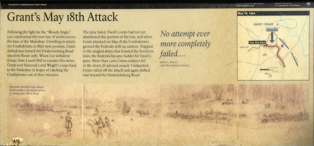
Grant’s May 18th Attack
Following the fight for the “Bloody Angle,” Lee constructed this new line of works across the base of the Muleshoe. Unwilling to attack the Confederates in their new position, Grant shifted east toward the Fredericksburg Road (modern Route 208). When Lee withdrew troops from Laurel Hill to counter this move, Grant sent Hancock’s and Wright’s corps back to the Muleshoe in hopes of catching the Confederates out of their trenches.
The ploy failed. Ewell’s corps had not yet abandoned this portion of the line, and when Grant attacked on May 18 the Confederates greeted the Federals with 29 cannon. Trapped in the tangled abatis that fronted the Southern lines, the Federals became fodder for Ewell’s guns. More than 1,200 Union soldiers fell in the short, ill-advised assault. Undaunted, Grant called off the attack and gain shifted east toward the Fredericksburg Road.
No attempt ever more completely failed ….
James L. Bowen
17th Massachusetts Infantry
Caption to the background drawing:
Hancock’s Second Corps charges Ewell’s works in this pencil sketch by sketch-artist Alfred Waud.
Location of the markers
The Confederate Earthworks and Grant’s May 18th Attack wayside markers are not at a tour stop but are at the western end of Anderson Drive about 1/3 mile west of Tour Stop 4. Anderson Drive used to connect through to Brock Road but now ends here at a small parking area. (38°12’51.4″N 77°36’28.0″W)