
Battle of Fisher’s Hill • Tour the Battlefield • 1864 Shenandoah Timeline
When you tour the Fisher’s Hill battlefield today you will find much of it is still the wooded countryside it was in 1864. The Valley Pike has been upgraded and realigned for modern traffic and there are some new buildings, but the feel of the fields and woods is probably little changed. Even the railroad was here in 1864. The one exception is Interstate 81, which splits the field in half like it does on so many other Shenandoah battle sites.
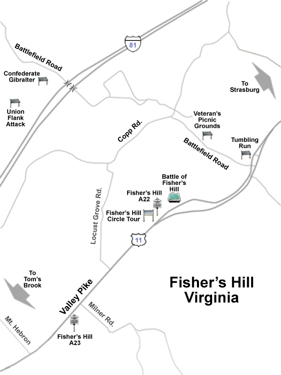
There is just one small monument on the field and only a few historical or wayside markers. Most are down on the Valley Pike to let the passing traveller know they are crossing historic ground:
Battle of Fisher’s Hill A22 Virginia historical marker
Battle of Fisher’s Hill A23 Virginia historical marker
Battle of Fisher’s Hill Circle Tour marker
Battle of Fisher’s Hill Monument
Fisher’s Hill – Confederate Gibraltar wayside marker
Fisher’s Hill – Veteran’s Picnic Grounds wayside marker
Fisher’s Hill – Union Flank Attack wayside marker
Valley Pike – Tumbling Run near Fisher’s Hill wayside marker
Turning northwest up the aptly named Battlefield Road brings the visitor along the foot of Fisher’s Hill itself. The road follows Tumbling Run, the stream that carved the ravine that made Fisher’s Hill a natural fortress. Confederate defenders lined the high ground on the southwest side of of the road while Union forces gathered on the other side.
After passing under the Interstate there is a parking area on the left for the Civil War Trust’s Fisher’s Hill Battlefield site. From there a trail leads 0.4 mile up the hill to the top of the hill. This was the left flank of the Confederate infantry line; dismounted cavalry filled the gap beyond this point. It features a lookout tree used during the battle, an outstanding panorama of the countryside and, bless their hearts, a bench to sit and enjoy the view after your climb.