
Cedar Creek • Tour the Battlefield • Battle Maps • The Armies
A monument and several historical markers are on the north end of the battlefield:
Monument to Colonel Charles R. Lowell
Battle of Cedar Creek A15 historical marker
Defense of the Cemetery wayside marker
End of Sheridan’s Ride historical marker
The Cauldron wayside marker
Engagement at Middletown Virginia historical marker
The Fatal Halt 10:30 a.m. wayside marker
Heater Fields wayside marker
Sheridan Arrives 10:30 a.m. wayside marker
Union Counterattack wayside marker
Cedar Creek Auto Tour
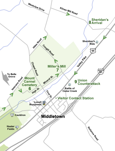
Continuing from the Belle Grove tour page on Meadow Mills Road, turn left onto Veterans Road for 0.4 mile. Turn right onto 4th Street (State Route 635) for 0.3 mile.
Stop 6 – Mount Caramel Cemetery. Stop at the small parking area in front of the second set of cemetery entrance gates. Visitors are encouraged to visit, but please be respectful of this active cemetery.
To continue to Stop 7:
Continue 0.3 mile northeast along High Street until it ends at Chapel Road. Turn right onto Chapel Road for 100 yards, then turn left onto Mineral Street for 0.5 mile. Turn right onto Cougill Road for 50 feet. Turn around into the small pull off on the left side of the road. You will be continuing north after the stop.
Stop 7 – Miller’s Mill. The Miller House is privately owned and not open to the public. There is a wayside marker at the stop. This marks the farthest advance of the Confederate army, which formed a line along Miller Lane, which is now Cougill Road.
To continue to Stop 8:
Return to the stop sign at the intersection (do not go over the train tracks, it is the wrong way). Turn right and continue northwest 0.8 mile on Cougill Road. Turn right onto Hites Road for 0.9 mile. Turn right onto Klines Mill Road for 0.9 mile.
Stop 8 – Sheridan’s Arrival. Park in the gravel on the right side of the small bridge.
To continue to Stop 9:
Continue 0.5 mile. Turn right (south) onto U.S. Route 11 for 1.4 miles. Turn left onto Skirmisher Lane (opposite Cougill Road). This is the 3rd entrance into the Laurel Ridge Community College campus.
Stop 9 – Union Counterattack Field
Stop 9 is at the parking lot at the southern end of the Laurel Ridge Community College campus. The “Battle of Cedar Creek” state historical marker is at the western end of the parking lot next to Route 11.
This is the last stop on the driving tour.